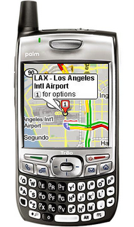
I think one of the best features of owning a PDA is the ability to carry mapping applications on it. I currently use Mapopolis as my map program and it has proven to be quite helpful in me finding my way. However, Palm recently announced their new Treo, the Treo 680, and with it came Google Maps for Treo. Google Maps for Treo is a PDA version of the Google Maps online.
Google Maps for Treo also supports other Palm OS 5 devices like the Palm Lifedrive and the Palm TX. I’ve used it on my Lifedrive and wanted to share my thoughts on this invaluable tool.
Google Maps for Treo works just like the online version. You can type in an address and the map will display that location. You can choose between the satellite view and the regular map view. The satellite view works quite well on my Lifedrive and it looks great. Google Maps for Treo will also give you door to door driving directions. I tried plotting the route from my house in Buffalo, NY to my parent’s home in Pensacola, FL and the program had no problems displaying the route. I had step by step directions and I went through them and they seemed quite accurate. I also plotted my house to my church and again the directions came back quickly and accurately.
Could this replace a program like Mapopolis? Well, for now, Google Maps for Treo doesn’t offer GPS support. Mapopolis does. That said, Google Maps for Treo is free and covers all of the US and six other countries. If GPS is important to you, then an app like Google Maps for Treo probably won’t be an app for you. For those that don’t require GPS and can have a wireless connection, this app will rock. You have all of the US available to you. A huge plus in my opinion.
Google Maps for Treo has quite a bit of features. This program offers real-time traffic (covers over 30 major US metropolitan areas), detailed directions, integrated search, easy movable maps, Favorite places and routes, Insta-KB-o-meter, and satellite imagery. I think a nice feature is the Insta-KB-o-meter which helps you watch your data consumption especially if you are not on a unlimited plan. I’ve also tried the traffic information for Buffalo and it works well. Most of the time it reports gray, but I have seen a few greens.
To see how useful Google Maps for Treo can be I wanted to share two instances of how it has helped me. First off, my teenager guys and I went to a flag football tournament near Rochester. I pretty much knew my way to the church we were going to, but after the tournament we decided to go to the mall as many of us didn’t have power because of the October Surprise storm here in Buffalo. After we went to the mall, I had to find my way back to the interstate. I didn’t want to back track and I knew this must be a closer way back on, so I fired up the Lifedrive and used Google Maps to help. I didn’t have the address for the mall, but I knew the name of the mall and was able to find it thru Google Maps’ search feature. When in a matter of minutes, I found my way to the interstate and I didn’t have to backtrack at all. Last week, the secretary, the principal, and I were talking about the church’s daycare dryer which had died shortly after the storm. We were trying to find a local appliance store that was owned by a friend of the church. We could remember his name and the general location of the store, but not the store’s name, phone number, or address. While the secretary and the principal looked thru the phone book, I pulled out my Lifedrive and use Google Maps to search for the appliance business. From my Lifedrive I found the address and the phone number of the appliance store and we were able to call about getting the dryer fixed. Rather cool, huh?!
Overall, Google Maps is an amazing program and one that would surely be an essential app for you mobile device. Be sure to check out the Google Maps support device list and their virtual tour of Google Maps online.
0 comments:
Post a Comment